
Central Current
The downstream waters of the Onondaga Creek hardly suggest vitality — but Sid Hill remembers well-worn pathways leading to clearer waters.
For the Onondagas, the creek intertwined with sustenance and ceremony. All along the clear waters, trails led down to the creek’s banks, worn from regular use. Fishermen left their poles leaning in the crooks of fork sticks near preferred angling spots. Even in winter, fish could be seen swimming beneath the creek’s frozen surface.
Long before becoming the Tadodaho (spiritual leader) of the Onondaga Nation, a young Hill learned to swim in the creek where just about everyone learned to swim, he said, a favorite swimming hole off a country road in the Tully Valley. 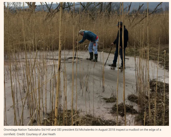
Springtimes would see Hill’s uncles netting bigger fish off a dam on the creek, bringing home their yield to be cleaned, fried and eaten at family gatherings. It was a spring ritual, Hill said, to pick wild onions, leeks and natural medicines found growing near the water.
But those rituals don’t happen anymore.
“Three generations now, haven’t done that. You don’t see the paths,” said Hill. “You go down to the creek there, and there’s no paths run. You don’t see these fork sticks sticking up.”
For over half a century, the once-clear creek has run brown with silt and sand that oozes above ground through holes called mudboils.
Across 35 years, various working groups, task forces, and teams of experts and public officials have researched, simulated, implemented and altered plans to mitigate the salty silt degrading Onondaga Creek. Past remediation efforts have addressed certain mudboils, only to be derailed by the emergence of new mudboils elsewhere.
The ongoing problem has no solution near in sight, while the Onondagas’ practices along the creek have been lost to the mire.
Onondagas noticed impacts on the creek’s clarity by the 1950s, when Hill, now 75 years old, and his generation were still kids. That decade also saw the peak of brining operations in the valley. The creek had become continuously turbid, and state investigators documented mudboils in the area. By the early 1970s, the Onondaga Creek was visibly muddy year-round from mudboil activity. Brining operations ended in 1988. When the mines stopped pumping brine to Syracuse factories, underground pressure increased — and so did the mudboils.
The 1991 collapse of the Otisco Road Bridge into the creek prompted initial efforts to solve the mudboil problem. The valley also experienced landslides that distributed sediment into the creek, including the 1993 landslide that spread 15 feet of mud across a 1500-foot area. For the next 15 years, mitigation efforts reduced the mudboils’ discharge from an average of 30 tons a day to half a ton a day.
But the emergence of “rogue” mudboils outside the mitigation measures effectively undid much of the previous work to reduce the amount of silt flowing into the creek. The result was a creek whose flow resembled the turbid waters of 1991.
In 2014, the Nation and other stakeholders hoped a forthcoming study from a newly formed mudboil technical advisory group might identify a lasting solution.
Over a decade later, scientists are still researching the viability of proposed mitigation plans, and the Onondaga Nation is still waiting for clarity.
‘Between a rock and a mudboil’
Tully Valley mudboils were first documented in the late 19th century, including in a 1899 Post- Standard article describing a “sand and water volcano.” The valley is one of the only places on Earth where mudboils have been documented, and scientific research suggests they have likely occurred for thousands of years.
A causal relationship between regional salt mining and modern mudboil output has yet to be proven, but the extractive operations of Allied Chemical (now Honeywell) have altered the land above and beneath the creek, according to United States Geological Survey reports.
In 2015, a research paper commissioned by the Onondaga Nation and published by Chazen Companies found “a preponderance of evidence linking these phenomena to brine mining activities.”
Honeywell through Director of Communications Caitlin Leopold declined a Central Current reporter’s request for an interview for this story.
For nearly a century, Allied conducted solution salt mining in the Tully brine fields, extracting over pumped water into underground salt caverns, creating brine and pumping it to the surface. The operations carved vacuums below the Tully Valley, causing land subsidence and creating sinkholes. Above the creek, hillsides are slashed with numerous rock fissures, gaping cracks in the ground that opened as a direct result of the salt mining operations.
The USGS in 2009 reported over 400 such fissures, some with depths of over 50 feet.